Home > Semiconductors & Electronics > Sensors > LiDAR > LiDAR in Mapping Market
LiDAR in Mapping Market Analysis
- Report ID: GMI4461
- Published Date: Nov 2022
- Report Format: PDF
LiDAR in Mapping Market Analysis
The drone segment of the LiDAR in mapping market is estimated to record around 30% growth rate through 2032. Drones are recognized as the most promising platforms for LiDAR mapping due to their ability to facilitate aerial mapping and surveying. They are lightweight and compact tools that ensure stability, making a flight in difficult terrains and extreme weather conditions easier. An increasing number of adverse events and disasters is stimulating the need for LiDAR mapping for disaster and post-disaster assessment. Advancements in unmanned aerial vehicles (UAVs) will also improve LiDAR output with cost-effective, and faster accumulation of high-resolution data.
The Fixed-wing drones held about 50% of the LiDAR in mapping market share in 2022. Rise in recreational activities and growing focus on high-quality aerial photography during mapping will enhance the need for fixed-wing drones. These drones have a wide range of commercial applications and are designed to ensure smoother flights by leveraging natural gliding capabilities. Fixed-wing drones are gaining momentum owing to their ability to fly faster than multirotor drones which allow these machines to cover longer distances. These equipment enable mapping at higher altitudes, as their gliding design can effectively sustain in thin air conditions.
LiDAR in mapping market from the mobile segment is anticipated to exhibit more than 25% CAGR through 2032. Rapid penetration of mobile devices such as smartphones and increasing investments in the development of novel LiDAR solutions will complement industry growth. Mobile LiDAR refers to an archive of LiDAR point clouds across a moving platform. These devices include a series of LiDAR sensors mounted on any type of mobility system right from trains to boats. Mobile LiDAR is an effective mapping tool that uses laser scanning to identify roadway assets and understand related infrastructure accurately, quickly, and cost-effectively.
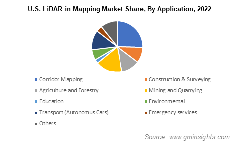
The Transport (autonomous cars) applications is poised to witness nearly 30% gains up to 2032. Over the last decade, both developed as well as developing nations have undergone dynamic urbanization and industrialization thus propelling the need for robust town planning. Several public and private organizations worldwide are heavily investing in autonomous mapping facilities to proliferate the integration of LiDAR in transportation and autonomous vehicles. Growing consumer interest in next-generation mobility solutions is encouraging automakers to develop innovative features such as distance mapping, night vision, and pedestrian detection systems.

The Europe LiDAR in mapping market will capture approximately 20% of the industry share by 2032. Expanding data-intensive geological applications and growing demand for high-quality elevation information will consolidate industry expansion across Europe. The region supports technological advancements in the field of geology allowing accurate 3D modeling of landscapes. LiDAR mapping is helping EU countries including the UK and Germany with data needs for preparedness pertaining to disasters with the help of 3D models of river catchment areas.
In recent years, European countries have reported a surge in climatic hazards, accelerating the need for accurate and precise disaster management tools. For instance, in August 2022, Iceland reported a burst of nearly 4000 earthquakes in Reykjanes Peninsula, which increased the risk of a volcanic eruption in the country. The increasing requirement to raise the alert levels in such instances will assist higher adoption of LiDAR systems in the near future.

